Our walk, ‘As The Crow Flies’, part of the renown Jane Jacobs Janes’ walk network,took place last Sunday afternoon in Stirchley, Birmingham. We started at two different points on each side of the Rea Valley and tried to meet in the middle. We wanted to make a public walk because we think Hazelwell Lane is important in terms of moving through Stirchley and that involving the community in the design and layout of its public realm is vital to ensuring it works well for them. Hazelwell Lane was closed to the public by Tesco in late 2016 and despite assurances in early 2017 when they withdrew from development they have not reopened the road. Tesco are now selling their land instead of building a supermarket and it seemed timely to revisit the site as a community.
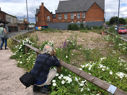
The walk was full of questions about the future of the area and its overall connectivity, with Hazelwell Lane being key to movement. We know from our visit to Hazelwell Allotments and personal experience that the closing off of this road is a major inconvenience and creates a disconnect in the area. Our route from Bournville Station took us past all 6 of the sites for sale by Tesco. Proceeding from Maryvale Road brought us to Pershore Road and past lot 1, an overgrown square shaped parcel, fenced off for years, past lot 2, the old Kwik Save (now sold apparently). Then to the Triangle, an open space, but prior to demolition a reclamation yard. The Tesco plans were for it to be a public ‘square’, and Stirchley Birds undertook initial design development work with BPN architects to develop a concept for the public realm that would benefit the Stirchley area. Will the Triangle remain an open space?
The group chose to walk around the gyratory instead of taking the direct route so they could look at how connections could be made across the gyratory and link to Bournville Lane and Stirchley Park. The group recalled how a pocket of land opposite the Friends Meeting House was promised to the community around the time of the loss of the bowling green to the baths car park.
Connectivity across the gyratory would be ideal. There is a line of site and a desire line waiting to be walked.
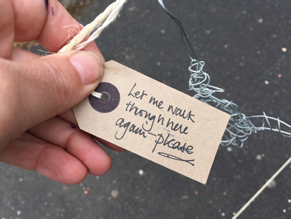
And then onto the final 3 lots of land and we arrived on Hazelwell Lane, always the low point in the valley, but now a low point experientially. It’s so frustrating to be able to see where you want to be able to go and not be able to go there, due to the carelessness of a corporation. And to know that everything that was there before, from houses to community facilities has been removed, all value is gone. We made a poster of the main thoughts and questions we had during the walk and on arrival at the barrier.
The future of Stirchley’s connectivity revolves around retaining Hazelwell Lane. We need to know if Hazelwell Lane is still an adopted i.e. public road.
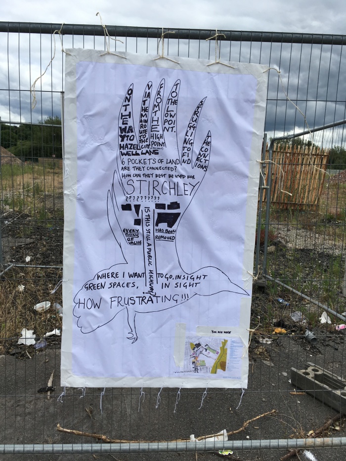
Another poster was made at the other side and small birds made their way along a wire across the land. The posters were left onsite – we welcome additions to the crows and would love it if you tweeted us when you do.
